The completion of the Overland Telegraph Line in 1872 between Adelaide and Darwin provided the impetus for further exploration and settlement of Australia’s vast interiors. In addition, the granting of huge pastoral leases throughout Northern Australia, saw the resultant development of a cattle industry, the emergence of the ‘Overlanders’, and the creation of Australia’s legendary droving teams.
Roads (as we know them) were non-existent, rail networks were in their infancy, and meat works (abattoirs) geographically distant. Just but a speck on the map of Australia, the Newcastle Waters Township emerged slowly in the early twentieth century.
Prompted by its geographical location, Newcastle Waters was situated at the crossroads of a number of cattle stock routes and the Overland Telegraph Line. This included the legendary and fearsome Murranji Track, which stretched from Top Springs to Newcastle Waters, a distance of 145 miles (234 km), and soon became known to early drovers as the ‘Death Track’ or the ‘Suicide Track’.
The Murranji takes its name from a desert frog capable of living underground for long periods without water. There were few permanent natural waters, and until 1924, a lack of Government bore sites. Drovers faced dense jungles of bulwaddy and lancewood scrub, and the prevalence of so called ‘drummy ground’. The phenomenon of cattle becoming ‘spooked’ by the echoes of their own hooves as they walked over the top of the many underground limestone caverns often led to panic with cattle rushing (or stampeding) and were a constant concern to Drovers. The Murranji Track was originally forged by a few early droving pioneers most notably the legendary Nat Buchanan who was also known as King Paraway.
Newcastle Waters Station was established in 1883 and continues today as a large and highly successful enterprise. Newcastle Waters grew slowly into a township. Affectionally known as The Ridge, the large movements of cattle from the Kimberley increased with the upgrading of the Government Wells along the Murranji and Barkly Stock Routes. The ‘droving plants’, characterised and led by legendary Boss Drovers, found Newcastle Waters the perfect location to seek respite before continuing their journey.
Whether they had just survived the Murranji, or were heading west to the Kimberley after traversing from either South Australia or Queensland, this was the place to purchase required stores for their journey and to refresh themselves at the Junction Hotel. From around 1920, the Newcastle Waters Township, originally established as a depot for the construction of the bores and, later on, the maintenance of these bores, began to develop.
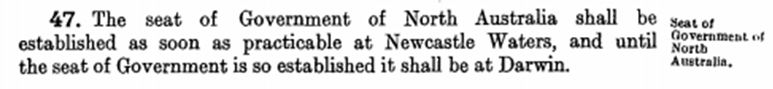
After Federation in 1901, the Government of South Australia seemed determined to relinquish their responsibilities and ownership of the Northern Territory. It was agreed that the newly-formed Commonwealth of Australia take control and it was eventually decided to split the Northern Territory into North Australia and Central Australia. The ‘Northern Australia Act’ was subsequently assented to on 04 June 1926 and Section 47 says it all:
However, it was not until 1930 that the Commonwealth Government resumed one square mile from the Newcastle Waters Pastoral Lease for the town site. The town was surveyed and saw the eventual establishment of the Junction Hotel, a general store, police station (already in existence from around 1914), church, an airport featuring a Qantas service and a Post Office. In (circa) 1934, Jones Store opened. This early-established business served as a general store, butchery, bakery and poultry business. Now owned by the National Trust, Jones Store has been faithfully restored by its hard-working volunteers. It represents a shining example of heritage preservation in such a (now) remote location.
The fate of both North Australia and Central Australia lasted but 5 years when in 1931, the ‘Northern Territory’ was re-established with its Administration still domiciled in Darwin. In the mid 1930’s, due to the imminent threat (or fear) of invasion, the progressive construction of the north-south road between Darwin and Alice Springs commenced. Resultant from the ongoing Japanese bombing of Darwin and Northern Australia, which commenced on the 19 February 1942, the north-south road was hastily upgraded and progressively sealed and was renamed the Stuart Highway in 1943.
As the causeway connecting the Newcastle Waters Township was regularly flooded, the Highway was constructed to the east of Lake Woods and Newcastle Creek and the Town of Elliott was established to provide an important ‘Staging Camp’ to support the convoys of military vehicles heading both north and south. During the war years, cattle droving (whilst somewhat diminished in numbers) continued. Beef was integral to the diets of both the visiting US Army and our own diggers and was, thus, in great demand. At the end of the war, the movements of large mobs of cattle recommenced in earnest. The Township of Newcastle Waters continued to flourish for a time.
However, in the 1960’s, the advanced development of road trains and the establishment of abattoirs in Darwin in 1963 and Katherine in 1964 saw Murranji droving numbers dramatically diminish. Government records confirm that droving numbers in 1962 were 24,550 head, reducing to 14,350 in 1963, and a mere 2,653 traversed the Murranji Track in the final year of 1967. At that stage, the maintenance of most of the bores ceased and scrub began to regrow along the Track. With this, the Township of Newcastle Waters virtually died a natural death.
The Junction Hotel closed in the mid 1960’s with its liquor license being transferred to the Elliott Hotel and Jones Store ultimately closing its doors in 1985 and the
Newcastle Waters Township was formally heritage listed on 11 November 1993.
Today, the Newcastle Waters School continues to operate and the massive Newcastle Waters Station homestead sits adjacent to the school, just outside the southern boundary of the Township. The well-respected and active Marlinja Aboriginal Community reside just beyond the western boundary of the heritage-listed Newcastle Waters Historic Township whose children attend the Newcastle Waters School.
![]()
Newcastle Waters History
Copyright Mates of the Murranji | Site by ![]()